NEWMAN — The Newman City Council on Feb. 24 will consider adopting a long‑range plan to redesign T Street and improve pedestrian and bicycle connections between neighborhoods, schools and parks.
The proposed T Street Corridor Improvement and Community Connectivity Plan was funded through a Caltrans Sustainable Communities Competitive Grant awarded in 2023. The $313,496 project includes a required local match of $35,957, which will come from the city’s Local Transportation Fund.
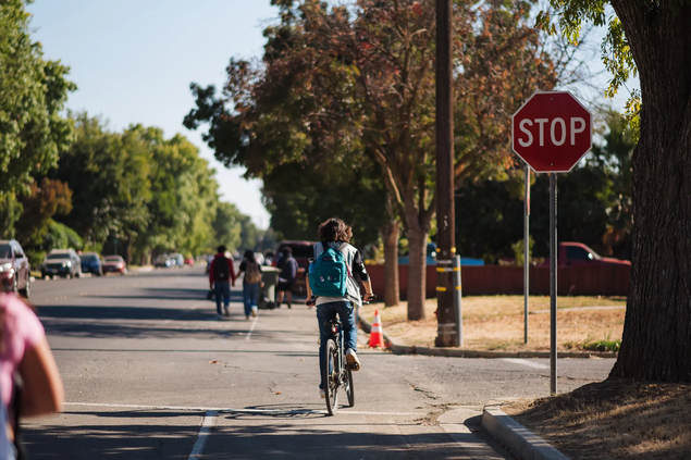
City officials say T Street is one of the most heavily used school routes in Newman, but currently lacks sidewalks, bike facilities and other basic safety infrastructure. Students walking or biking between neighborhoods and nearby campuses rely on the corridor daily, despite narrow shoulders, inconsistent crosswalks and limited separation from traffic.
To develop the plan, the city contracted with Toole Design Group, which began work in late 2023 with data collection, on‑site observations and a review of existing conditions. Over the next two years, the firm and city staff conducted surveys, community events, a three‑day design charrette and meetings with an advisory group to gather input from residents.
The study found that T Street and several connected corridors prioritize vehicle travel and lack continuous sidewalks, protected bike lanes and other features needed for safe multimodal travel. Residents raised concerns about speeding, uncomfortable walking conditions and gaps in the pedestrian network.
Despite those challenges, planners noted that Newman’s compact layout and the proximity of schools, parks and downtown destinations make the city well‑suited for walking and biking. T Street’s wide right‑of‑way offers opportunities to reconfigure the roadway, add protected bikeways and build continuous sidewalks.
The final plan centers on three goals — connectivity, access and safety — and outlines preliminary design concepts for T Street and several related corridors. If adopted, the plan would guide future investments and position the city to pursue construction funding in the coming years.
Council members will vote on a resolution to formally adopt the plan at Tuesday’s meeting.
WHAT THE T STREET PLAN WOULD DO
The plan covers the full length of T Street and four connected routes that together form the backbone of a future citywide walking and biking loop:
• T Street: Inyo Avenue to Yolo Street
• Hardin Road: Yolo Street to the northern terminus
• Yolo Street: T Street to N Street
• Inyo Avenue: West end of Yolo Junior High to Canal School Road
• Canal School Road: East Inyo Avenue to Hills Ferry Road
Viewed together, the corridors create the framework for a citywide lowstress bicycle and pedestrian loop, connecting schools, parks, downtown and future destinations such as the planned Nature Park.
The plan’s recommendations aim to:
• Rebalance roadway space to reduce speeding and improve safety
• Create lowstress walking and biking routes for all ages
• Strengthen the public realm with humanscale, welcoming streets
• Improve accessibility for children, older adults and people with disabilities
• Add placemaking elements that reflect Newman’s character
• Incorporate trees and green infrastructure to manage stormwater and reduce heat
• Align with the city’s General Plan, NonMotorized Transportation Plan and other adopted policies